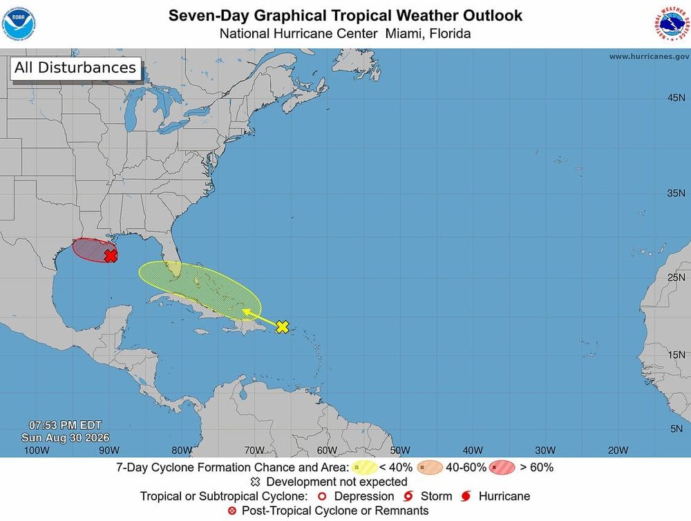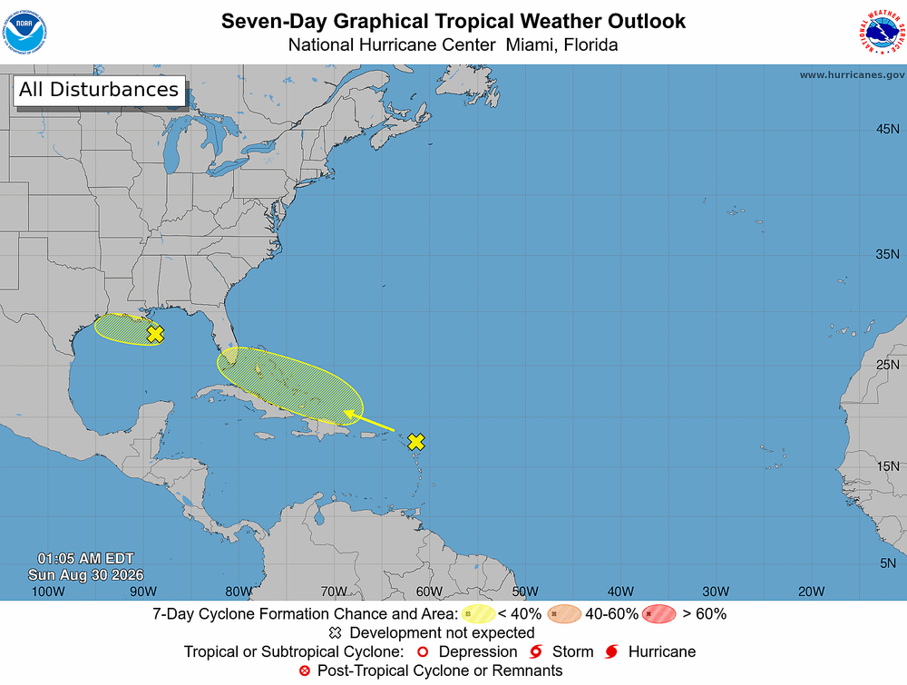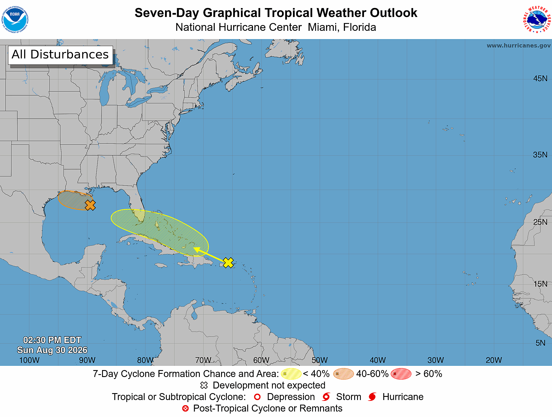
Forecasters raised development odds Sunday for a disturbance in the northern Gulf that could briefly become Tropical Storm Edouard before pushing onshore in Texas or Louisiana on Tuesday. A second system, the remnants of Tropical Storm Dolly, is drenching Puerto Rico and could reach Florida late this week.
Why it matters: Both systems arrive as Labor Day weekend approaches, and Florida is running a rain deficit.
[1 pm CDT Aug 30] The area of low pressure over the northern Gulf could become a short-lived tropical depression or storm as it drifts generally west-northwestward over the next couple of days. Regardless of development, locally heavy rainfall is expected across far southern… pic.twitter.com/elFERQnJ0x
— National Hurricane Center (@NHC_Atlantic) August 30, 2026
A Fast, Modest Gulf Storm
The National Hurricane Center bumped formation odds for Invest 97L to 30% over both 48 hours and seven days as of Sunday afternoon. Forecasters assign the "invest" tag to systems under investigation. Some meteorologists put the odds higher, near 50%, citing warm water and light wind shear along its westward path.
Key details:
- The low sits about 125 miles south of southeastern Louisiana and has produced more concentrated thunderstorms, though surface observations show it has not yet strengthened.
- Hurricane Hunter aircraft are scheduled to investigate the system beginning Monday morning.
- Dry air and a short runway over water work against it. Landfall is expected along the southeast Texas or southwest Louisiana coast on Tuesday.
- Houston could pick up 1 to 2 inches of rain this week even without development.
Small storms cut both ways. They can strengthen quickly, and they can fall apart just as fast. Expect heavy rain, pockets of flooding, gusty wind, higher tides and an isolated tornado threat regardless of whether it earns a name. Edouard is next on the 2026 Atlantic list.
Rain Where It's Needed
Dolly weakened to an open tropical wave last week and its remnants passed near Puerto Rico on Sunday, bringing scattered showers and storms to an island where 44% of the land is in Level 4 "extreme" drought. The remnants also gusted to 60 mph on Saba earlier in the day.
The NHC gives redevelopment a near zero chance in 48 hours and 20% over seven days, noting satellite and surface data show no closed circulation as the wave races west at about 25 mph. Conditions may turn more favorable by midweek as the system nears Florida and the eastern Gulf.
The open question is what arrives, not whether moisture does. Some models show Dolly reforming, and it would keep the name. Others show the mountains of Puerto Rico and Hispaniola tearing it apart. Florida timing spans Thursday at the earliest to Labor Day at the latest, and the track range remains wide.
What To Watch Next
Monday's Hurricane Hunter data will settle whether 97L has a closed center. Tuesday reveals what, if anything, survives of Dolly. Neither system currently threatens Florida with significant wind, but both carry rain the state needs.