The Atlantic is beginning to show more signs of life as Florida moves deeper into August and toward the historical peak of hurricane season.
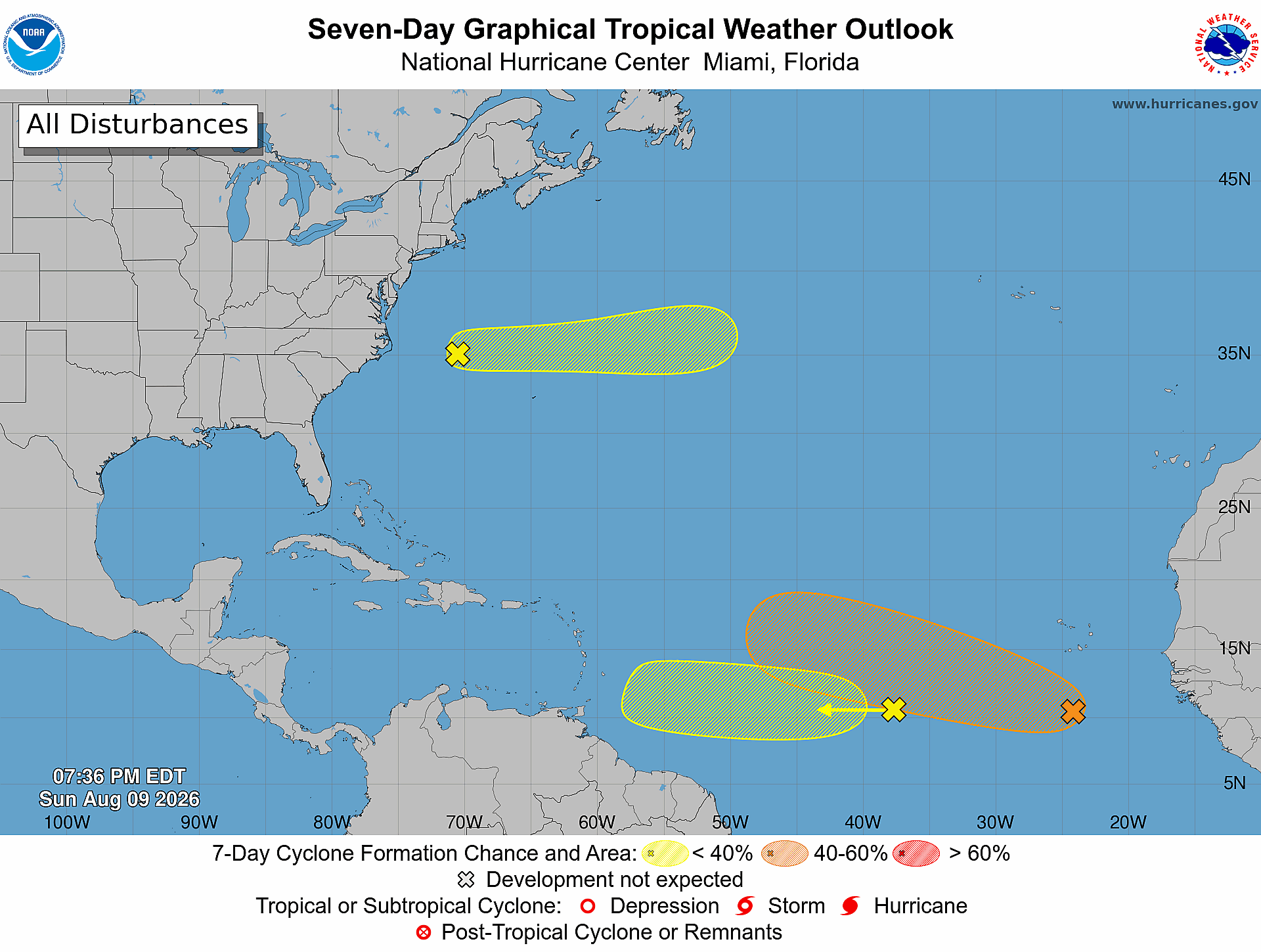
As of Sunday evening, Aug. 9, the National Hurricane Center was monitoring three areas of disturbed weather across the Atlantic, including one that now has a 50% chance of becoming a tropical depression or storm during the next seven days.
There is no immediate threat to Tampa Bay or Florida from any of these systems. But the increasing activity thousands of miles away is exactly why preparedness matters now.
The system getting the most attention
A small area of low pressure has developed several hundred miles south of the Cabo Verde Islands, off the western coast of Africa.
The National Hurricane Center expects it to merge with a tropical wave over the next couple of days. Conditions could then become more favorable for organization by the middle of the week.
Forecasters give the system a 10% chance of developing within 48 hours and a 50% chance within seven days.
A tropical depression could form during the second half of the week as it travels west to west-northwest across the central Atlantic.
If it eventually strengthens into a named tropical storm, Cristobal would be the next name on the 2026 Atlantic hurricane list.
Development, however, does not mean Florida impact. The system remains far out in the Atlantic, and it is much too early to know whether it will eventually approach land.
Two other Atlantic areas are being watched
Another tropical wave roughly halfway between Africa and the Lesser Antilles has a 20% chance of development over seven days. The National Hurricane Center says conditions should become less favorable as it approaches the Lesser Antilles later this week.
A third disturbance northwest of Bermuda has only a 10% chance of developing and is expected to remain well north of Bermuda while moving toward cooler water.
For Tampa Bay, neither currently presents a threat.
The Pacific is much busier
The contrast between the Atlantic and Pacific is significant.
A disturbance about 1,100 miles east-southeast of Hawaii has a 90% chance of developing within seven days, with a tropical depression expected to form by midweek.
Two additional systems are being monitored in the eastern Pacific, including one with a 60% seven-day development chance.
While those systems don't threaten Florida, they illustrate an important point about the influence of El Niño: conditions that can suppress Atlantic hurricane activity can simultaneously favor more tropical activity in parts of the Pacific.
A quieter season doesn't mean Tampa Bay can let its guard down
The Atlantic has been relatively quiet, but seasonal forecasts tell us how active the entire Atlantic may be — not whether Tampa Bay will be struck by a storm.
It only takes one.
August also marks the beginning of the Atlantic's traditional ramp-up toward its climatological peak in September. Tropical waves routinely move west from Africa during this period, and conditions can change considerably during their weeklong journeys across the ocean.
That's why Tampa Bay households shouldn't wait for Florida to appear inside a forecast cone before preparing.
Use the quiet time to prepare
Before a storm threatens the Gulf, residents should review evacuation zones and routes, know where they would go if ordered to evacuate, check flood risk and insurance documents, and make sure emergency supplies are ready.
Keep enough food, water, medications and essential supplies to remain self-sufficient following an emergency. Charge backup batteries, test generators safely outdoors, make plans for pets and family members with additional needs, and determine how you'll receive emergency alerts if power or cellular service is disrupted.
Most importantly, don't use today's lack of a Florida threat as a reason to postpone preparation.
The Atlantic is beginning to wake up. Tampa Bay's best opportunity to prepare is while every system is still far away.